Yahoo Answers is shutting down on May 4th, 2021 (Eastern Time) and beginning April 20th, 2021 (Eastern Time) the Yahoo Answers website will be in read-only mode. There will be no changes to other Yahoo properties or services, or your Yahoo account. You can find more information about the Yahoo Answers shutdown and how to download your data on this help page.
Trending News
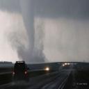
***MS/LA TORNADO WATCH in effect***?
There is an 80% probability of having 2 or more tornadoes with this watch, and a 40% prob. of one or more strong tornadoes.
THUNDERSTORMS EXPECTED TO INCREASE IN NUMBER AND INTENSITY ACROSS WRN MS WITH APPROACH OF STRONG UPPER TROUGH. DEEPENING SURFACE LOW SERN AR WILL TRACK NEWD INTO NRN MS WITH ENHANCEMENT OF LOW LEVEL SHEAR IN WARM SECTOR ACROSS MUCH OF MS. SUPERCELLS INCLUDING TORNADOES AND DAMAGING WINDS WILL BECOME LIKELY BY LATER THIS AFTERNOON AND DEVELOP EWD ACROSS WATCH AREA.
*Listen to a NOAA Weather Radio or local radio or television stations for updated information.
* Be alert to changing weather conditions. Tornadoes accompany severe thunderstorms, and weather conditions can change rapidly. Large hail, blowing debris, or the sound of an approaching tornado may alert you. Many people say approaching tornadoes sound like a freight train.
It do not think that the threat for tornadoes will reach as far north as Nashville. Some of these storms should move through overnight and the biggest threat will be strong winds in Nashville.
4 Answers
- WRLv 51 decade agoFavorite Answer
Updated MD for the watch
THE SEVERE WEATHER THREAT FOR TORNADO WATCH 92 CONTINUES.
WIDESPREAD CONVECTION PERSISTS ACROSS THE LOWER MS VALLEY REGION
AHEAD OF ADVANCING COLD FRONT. OF PARTICULAR NOTE IS THE GRADUAL
INCREASE IN BOUNDARY LAYER MOISTURE ACROSS SRN MS WHERE DEW POINTS
ARE NOW RISING INTO THE MID 60S. THIS INCREASE IN LOW LEVEL
MOISTURE SHOULD ENHANCE AN OTHERWISE MEAGER INSTABILITY
ENVIRONMENT...MOST LIKELY THE PRIMARY IMPEDIMENT FOR MORE ROBUST
SUPERCELLS. EVEN SO...A FEW LONGER LIVED...POTENTIALLY TORNADIC
SUPERCELLS ARE NOTED AHEAD OF THE FRONTAL SQUALL LINE FROM SERN LA
INTO CNTRL MS. THIS ACTIVITY IS EMBEDDED WITHIN A BROADENING BAND
OF PREFRONTAL STORMS THAT SHOULD SPREAD INTO ECNTRL MS OVER THE NEXT
FEW HOURS.
- 1 decade ago
Im in nashville,Tn we are to, I am at work and we have a wooden fence in the back of work, It has blown it down already and I hasnt done that ever, in the last 2years, and we had some tornados come thorugh to, GOOD LUCK EVERYBODY.
- paredezLv 45 years ago
A twister watch is issued even as the typhoon prediction middle has a good feeling a twister ought to take position in that area. I watch in basic terms skill to keep eyes to the sky and do your time-honored belongings you do and in basic terms be alert for plausible warnings in a lengthy time period. a twister caution is issued even as a twister has been considered or dopper radar has picked up roation contained in the thunderstorm that ought to produce a twister.
- Blueberry ManLv 51 decade ago
I don't think it's coming THIS WAY (Nashville)
Stay safe and listen to Mr. Weather